
Issue 99: The Map Is Not the Corridor
New maps imagine the future of trade after the Hormuz shock. For now, oil is moving by truck.

Since Israel and the United States launched military strikes against Iran on February 28, 2026, the Strait of Hormuz has remained effectively closed. Roughly 20% of the world’s seaborne crude oil and a quarter of its LNG exports normally pass through the strait; flows have fallen sharply, with only limited volumes moving in the past two months. Brent crude has climbed roughly 20% to around $100 a barrel, with Asian LNG spot prices up closer to 40% – a sharp increase even if it isn’t as high as originally predicted.
The Strait of Hormuz’s challenging geography was never a secret. Twenty-one nautical miles wide at its narrowest, it is the only sea route from the Persian Gulf to the open ocean. Saudi Arabia, the UAE, Kuwait, Qatar, Iraq, and Iran itself all export through it. Today’s largest consumers of Gulf fossil fuels - China, Japan, South Korea, India - have no alternative supplier base on an equivalent scale.
For this reason, major oil producers built in redundancies to offset some of the risks of relying on the safe passage of tankers across such troubled waters. Saudi Arabia’s East-West pipeline (or Petroline), in service since 1981, can carry up to 5 million barrels per day from the eastern city of Abqaiq to Yanbu on the Red Sea. The UAE’s Habshan-Fujairah pipeline (ADCOP), operational since 2012, adds another 1.5 million barrels per day to a port outside the Strait. Without these redundancies, the global economic forecast would be considerably more grim.
The Strait of Hormuz is far from the first Middle Eastern chokepoint to have been tested in recent years. The meme-worthy Ever Given grounding in March 2021 closed the Suez for six days, exposing how thin the margin is between functional trade and global disruption. Supply shocks were a key feature of the Covid era. Similarly, the Houthi campaign against Red Sea shipping from late 2023 onward put the Bab el-Mandeb Strait on the same infamous list of vulnerable chokepoints. Each event pointed to the region’s vulnerabilities, and the Strait of Hormuz is just the most visible of this broader pattern.
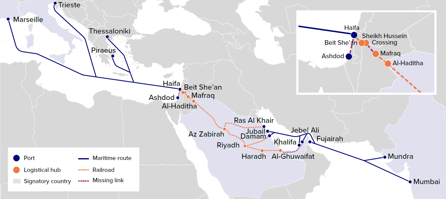
Given those vulnerabilities, geopolitical and commercial actors have spent years identifying possible alternative routes. One example is the India-Middle East-Europe Economic Corridor (IMEC), announced at the G20 summit in New Delhi in September 2023 - weeks before October 7th. IMEC was meant to be the big answer to the many challenges facing East-West trade, establishing points of connectivity that would serve as the foundation for a more integrated regional model while also offering a strategic alternative to China’s Belt and Road Initiative (BRI).
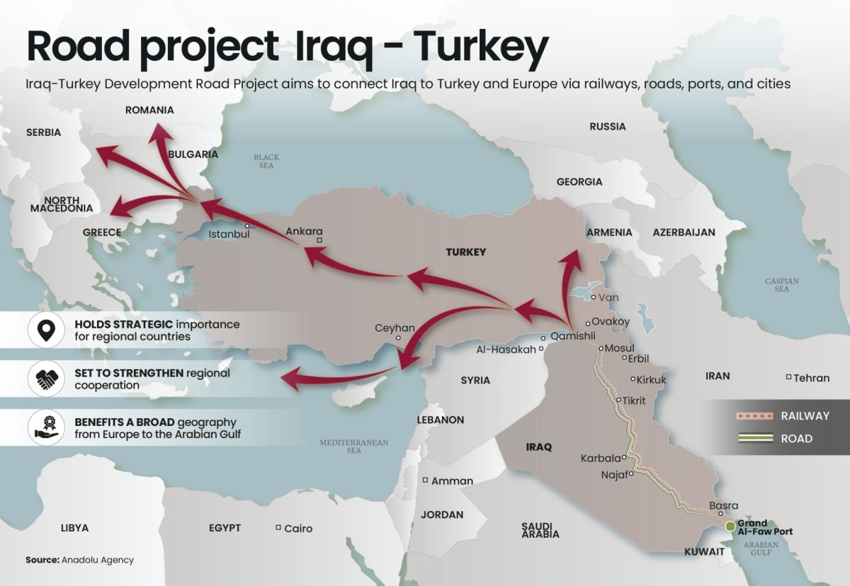
The Iraq–Turkey Development Road, presented around the same period, made similar promises.
Despite recent enthusiasm, both of these projects remain in the “digital map” phase. The political, commercial, and technical constraints that limited them before the war remain in place. The multilateral cooperation that these maps presupposed has not materialized; wars in Gaza, Syria, and Iran have yet to pave the way toward a more integrated region.
What has changed is the sense of urgency.
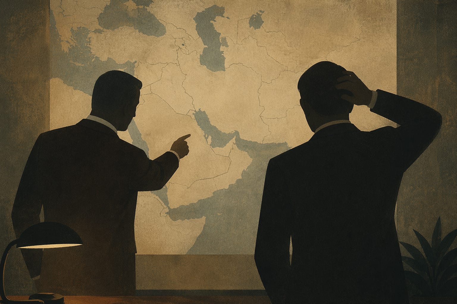
Here are some recent maps that have surfaced since February 28th that offer a response to the Hormuz closure. They are not competing answers to the same problem. They are competing claims about who gets to shape the region after the war - and each implies a number of potential stakeholders. The fewer parties required to collaborate, the more likely the project can be realized.
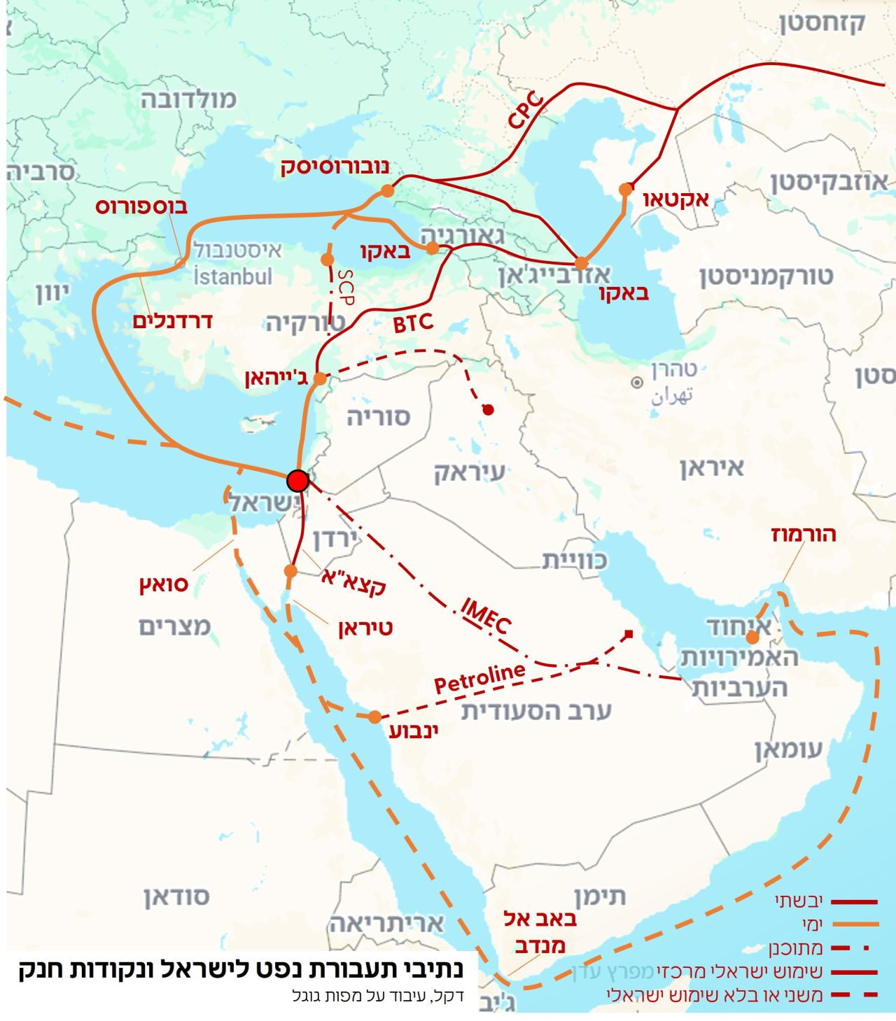
The first, a Hebrew-language map, centers Israel and the region’s chokepoints - Bab el-Mandeb, Bosphorus, Suez, Hormuz - while tracing the overland and maritime routes that could one day bypass them. IMEC terminates at Haifa; the Petroline arcs across Saudi Arabia to Yanbu; Caspian Pipeline Consortium (CPC) and Baku-Tblisi-Ceyhan (BTC) reach the Mediterranean through the Caucasus. As presented, the proposed regional alternatives all run centrally through Israeli infrastructure like arteries delivering blood to the heart.
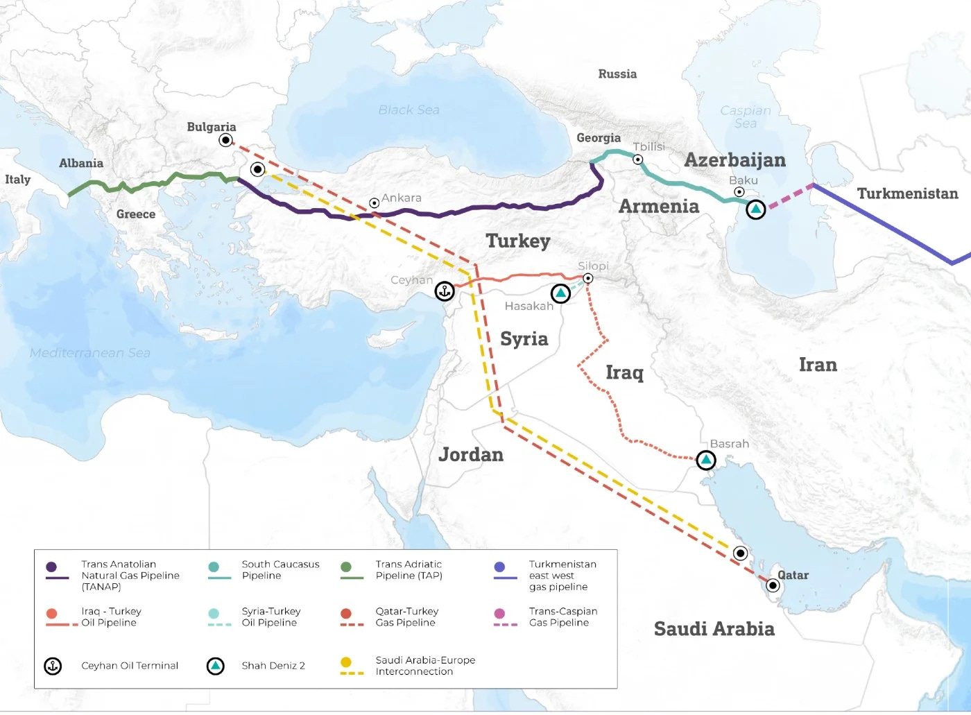
The second, published by Middle East Eye, surveys East-West connectivity options running through Turkey: TANAP, BTC, the South Caucasus Pipeline, the Iraq-Turkey oil line, and dashed variants for Qatar-Turkey, Syria-Turkey, the Trans-Caspian, and the Saudi Arabia-Europe Interconnection. The framing is Turkey-centric by design, and defensibly so: a meaningful share of plausible East-West routes does cross Turkish territory. In the words of Turkish Energy Minister Alparslan Bayraktar (President Erdogan’s son-in-law), “So, you have no LNG exports. You already cannot move through Hormuz. Now imagine that a certain amount of gas is being sent to Turkey and Europe through a pipeline…We are opening an alternative export route for you.” The pitch has almost an air of inevitability to it.
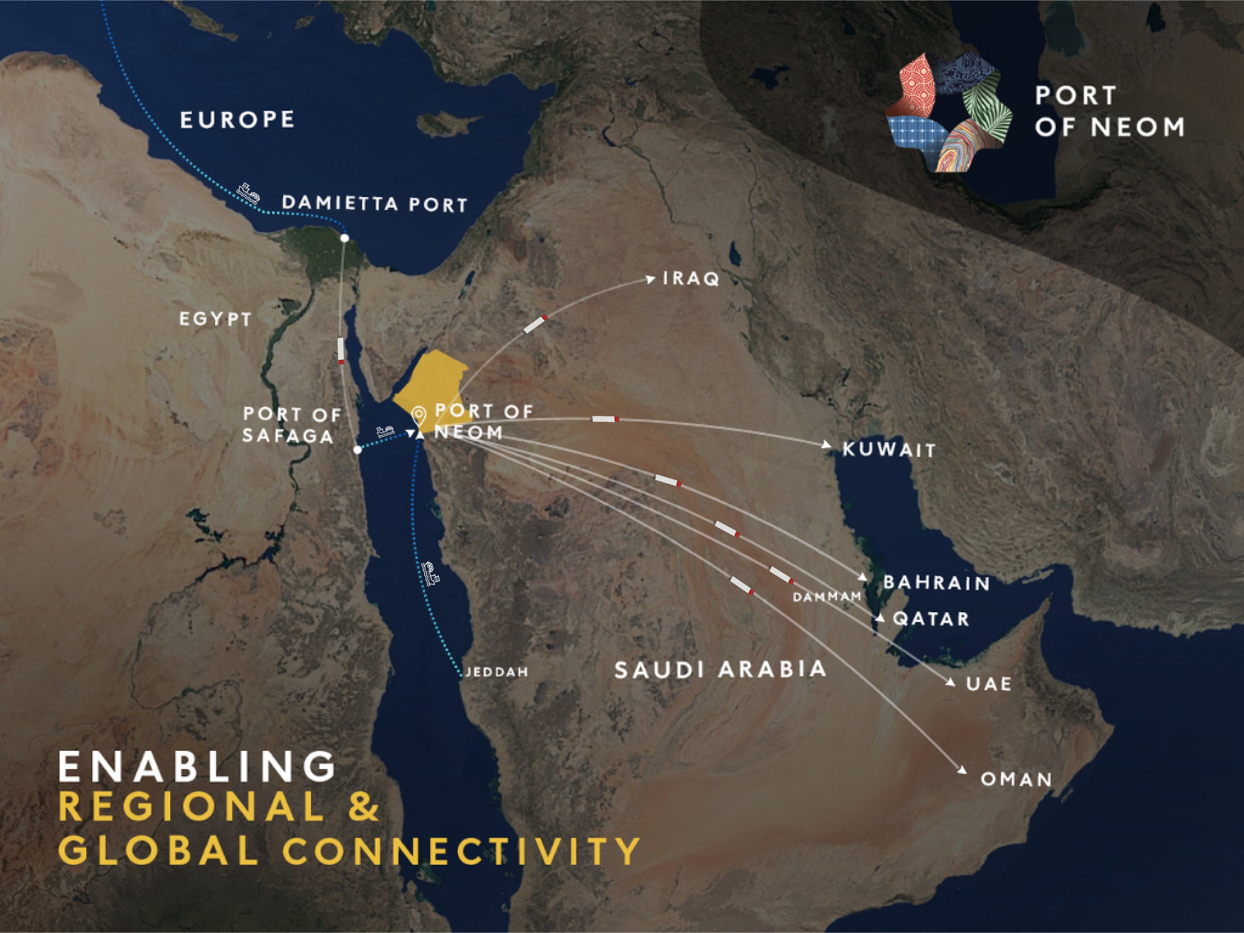
The third was published by the communications team of Saudi Arabia’s planned city, NEOM, and is openly promotional. The Port of NEOM is the hub, with dotted lines radiating outward to every Gulf capital and onward to Europe via the Red Sea. The Strait of Hormuz appears on the map, but is peripheral. Saudi Arabia is imagining a future in which it sits at the center of regional trade, and the Hormuz chokepoint becomes someone else’s problem.
Read closely, these maps are not responses to the immediate problem of stranded volumes. They are bids for long-term alignment - proposals for how trade, capital, and political risk should be reorganized in a post-war environment. At first glance, the NEOM vision requires the fewest external parties to say yes; it is Saudi infrastructure, Saudi territory, connecting to established Red Sea lanes. But NEOM is a yet-to-be-completed and beset by challenges. Like IMEC, the Israel-centric map is conditional on regional normalization - a high bar under current conditions. The Turkey-centric map sits somewhere between: some underlying infrastructure already exists, and Ankara has demonstrated willingness to function as a transit hub regardless of broader regional alignment, but it still depends on a wide cast of stakeholders whose interests do not always converge.
The political constraints are the deepest ones. Each of these maps assumes a level of multilateral cooperation that the region has rarely sustained over the timelines these projects require. To make matters worse, every proposed corridor is interpreted by neighbors as a potential threat to its prosperity and stability. In that environment, the spoilers do not need to win. They only need to introduce enough uncertainty to make sure the rival projects fail.
It is worth remembering that large-scale infrastructure has been built in similarly fragmented environments before - the Baku–Tbilisi–Ceyhan pipeline crossed three states with active or frozen conflicts on their borders and was built anyway. But it benefited from several factors: the United States decided it mattered, British Petroleum agreed to take on the commercial risk, and the coalition of stakeholders was kept deliberately small. That combination - superpower backing, credible anchor investor, controlled stakeholder count - is precisely what is absent from many of the ambitious infrastructure projects circulating today.
Commercially, the math is also fuzzy. Energy does not move solely on maps; it also moves on insurance premiums. Premiums do not fall without political guarantees, guarantees require multilateral agreements, and the agreements that would underwrite a post-Hormuz regional architecture involve states whose alignment on such expansive and politically-sensitive projects is narrower than it looks on a diagram.
Technically, most of the projects depend on territories that are either contested or recently contested. The private sector doesn’t wait on political alignment; but it also doesn’t take unnecessary risks.
Instead, the gap is being filled by what can be improvised. One map circulating on X captures this dynamic perfectly: a vessel’s journey north through the Red Sea and Suez to the Syrian coast, overlaid with a hand-drawn arrow running overland from Iraq. Iraqi crude oil delivered to Syrian ports by truck, loaded onto tankers, shipped to European buyers. But reports suggest the plan can deliver approximately 140,000 barrels per day - less than 1% of normal Gulf throughput and vulnerable to logistical challenges at every step. This isn’t a solution - it is a workaround - the kind companies adopt when they can’t afford to wait for something better to come along.


These maps reveal less about what will be built than about who wants to be indispensable when the dust settles. The projects likeliest to be realized will be those requiring the fewest stakeholders - national initiatives insulated from multilateral entanglements, or bilateral arrangements with a clear anchor investor and a single transit state. The grand corridors will remain on their digital maps for now. Whether any of them escape the same fate as past infrastructure projects depends on a question that no map can answer: whether the pressures of the past months have been severe enough, and sustained enough, to push a critical mass of stakeholders to do something this region has rarely managed - cooperate, invest, and build together.
I welcome your questions. Here is hoping for better days, for the region and around the globe.
Gabi